Research Article | | Peer-Reviewed

Droughts in the High Continental Climate of Central Asia

Received: 12 January 2025     Accepted: 26 January 2025     Published: 11 February 2025
Views:       Downloads:
Abstract

Drought, one of the manifestations of emergencies, is a serious problem for Central Asia. Experts estimate that more than 70 per cent of the region's territory is considered vulnerable to natural disasters. Droughts are less frequent than floods, but affect more people. Over the past decade, 60 per cent of the population exposed to extreme weather events has been affected by drought. The most tangible impact of drought is on agriculture and food security in the region. Droughts are expected to become more frequent in Tajikistan, Turkmenistan and Uzbekistan due to projected temperature increases and longer periods of extreme heat and evaporation in areas with lower precipitation. In establishing drought monitoring and early warning systems in Central Asia and adapting drought prediction models, the monitoring of climate indicators and the availability of a rich and deep database of years is an important link. The purpose of this work is to monitor the probability of drought occurrence depending on the meteorological conditions of the Kafirnigan River basin in Tajikistan. The formation and dispersion zones of the Kafirnigan River differ significantly in their meteorological characteristics. The monitoring of droughts in the area of the river's formation and dispersion and their comparison with meteorological conditions allows establishing the existence of certain regularity between them. The results of such dependencies can form the basis for the development of drought early warning systems. A characteristic feature of the drought indices (SPI and SPEI) in the southern Tajik lowlands is their decreasing nature and the significant difference in the trends of change. Differences between SPEI-6 and SPI-6 are due to potential evapotranspiration (PET), which is determined by the difference between precipitation and evaporation. The similarity between SPEI and SPI in winter is reasonable because this is the period when PET tends to have the lowest ratio to precipitation, resulting in a functional approximation of SPEI to SPI. According to the same principles, the largest difference is observed in November, which covers the period from June to November, when PET is highest in relation to precipitation. It is found that for the period 1950-2023, monthly mean precipitation values are significantly lower and temperatures are higher than the climatic norm of the southern Tajik lowlands, leading to negative values of mean annual SPEI and SPI and favoring the occurrence of drought.

Published in International Journal of Atmospheric and Oceanic Sciences (Volume 9, Issue 1)
DOI 10.11648/j.ijaos.20250901.12
Page(s) 9-18
Creative Commons

This is an Open Access article, distributed under the terms of the Creative Commons Attribution 4.0 International License (http://creativecommons.org/licenses/by/4.0/), which permits unrestricted use, distribution and reproduction in any medium or format, provided the original work is properly cited.

Copyright

Copyright © The Author(s), 2025. Published by Science Publishing Group

Keywords

Drought, Kafirnigan River, Ayvaj, Bustonabad, SPEI, SPI, Correlation

1. Introduction
Drought, one of the manifestations of emergencies, is a serious problem for Central Asia. Experts estimate that more than 70 per cent of the region is considered vulnerable to natural disasters. Droughts are less frequent than floods, but they affect more people. Over the past decade, droughts have affected 60 percent of the population exposed to extreme weather events. This has had a significant impact on agriculture and food security in the region. Droughts are temperature increases and longer periods of extreme heat and evaporation in areas with less precipitation.
Continued glacial melt and reduced snow cover will exacerbate water problems in Central Asia. In addition, high temperatures and intense precipitation will lead to more frequent and intense natural disasters such as droughts, heat waves, floods, landslides, mudslides and avalanches. Over the past decade, more than 2,500 people have died as a result of natural disasters, and about 5.5 million people, or 10 per cent of the population of Central Asia, have fallen victim to the adverse effects of nature .
According to , the coming decade will be characterised by cycles of natural disasters, alternating between drought and flood years, as in 2000-2001 and 2002-2003.
The 2000-2001 droughts in Tajikistan and neighboring Central Asian states is estimated to have been the most severe natural disaster in recent decades. Much of Tajikistan's densely populated territory falls within the drought zone. Mild droughts are observed in isolated areas, while severe droughts cover large areas. During the study period (70 years), droughts covered most of the country's populated area simultaneously on eight occasions (1940, 1947, 1956, and 1971, 1980, and 1988, 2000-2001, 2007-2008). Particularly severe droughts occurred in 1971 and 2000-2001. The southern densely populated areas and the Gissar Valley suffer most from drought, with the highest number of years with moderate to severe drought. Due to climate warming, droughts are likely to increase in intensity and frequency in Tajikistan.
According to , droughts have resulted in about 20 percent of irrigated land regularly experiencing water deficits, ranging from 35 to 40 percent in Tajikistan. Droughts have had serious consequences for crop production and have also affected other agricultural sectors. During the droughts of 2001, 2003, 2008 and 2011, water levels in reservoirs and dams dropped sharply. As a result, a system of water restrictions had to be introduced throughout the country. In particular, the drought in the winter of 2008 led to an emergency situation with power cuts in Dushanbe.
The 2011 drought was severe, causing US$63 million in damage to the agricultural sector and affecting 2 million people. The agricultural sector was almost destroyed by the drought in Khatlon province, where the sector has yet to fully recover. The drought also reduced wheat, barley and rice production in agricultural areas receiving water from the Nurek reservoir by at least 75% compared to previous years. Precipitation and temperature scenarios using three climate models (CCSM3, ECHAM5 and CSIRO) and three greenhouse gas emission scenarios (A1B, A2, B1) show insignificant changes in precipitation in the Vakhsh and Pyanj river basins, with increased variability in high and low precipitation periods. At the same time, the composition of precipitation is expected to change, with an increase in rain and a decrease in snow. Intense precipitation with a frequency of once in 50 years will increase in a number of areas, particularly in the Pamirs. Geographically, annual precipitation is expected to decrease in southern Tajikistan. Summer and winter precipitation in Tajikistan is likely to increase, while spring and autumn precipitation may decrease. Temperature increases will be observed in all parts of the country. Winter and summer temperatures are likely to increase more in the Pamir and Hindu Kush mountains than in the valleys and desert plains.
By the end of the century, warming could be particularly pronounced in the southern parts of the country, the mountains of central Tajikistan and the western Pamirs. Daily maximum temperatures and heat waves will gradually increase, especially in the lowlands of southern Tajikistan. The risk of drought will increase due to increased evapotranspiration and earlier snowmelt.
Operational strategies, programmers and similar disaster management planning processes are relatively rare today, despite the obvious importance of drought in the region and the apparent trend towards increased vulnerability to drought. However, there are examples of good practice. In Tajikistan, the concept of participatory forest management has been tested in several projects and, once proven, was incorporated into the Forest Code and the relevant law in 2011 and 2012 respectively.
To ensure the sustainable development of the agricultural sector, the Government of the Republic of Tajikistan has adopted a number of measures to support and stimulate farms, and several sectoral programmers have also been adopted: "Horticulture and Viticulture Development Programme for 2016-2020" and "Comprehensive Livestock Development Programme for 2018-2022", the implementation of which has contributed to a significant increase in production, enrichment of the country's consumer market and export growth.
The "Programme for the Development of Horticulture and Viticulture in Tajikistan (2016-2020)", which prohibits the use of flat arable land for horticulture, has encouraged the widespread use of rainfed land on hillsides and in mountainous areas.
The minimization of the risks of climate change and natural disasters (floods, avalanches, droughts, etc.) is carried out through the development of institutional mechanisms and commitments, which are disseminated among various governmental structures, agencies and non-governmental associations.
Currently, the Government of the Republic of Tajikistan has adopted more than 50 laws and regulations in the field of climate change and environmental protection. More than 10 state programmers and action plans have been approved, national centers for coordination and resolution of environmental problems of national and global scale have been established: the National Action Programme on Desertification in Tajikistan, the National Strategy of the Republic of Tajikistan for Disaster Risk Reduction for 2019-2030, the National Strategy of the Republic of Tajikistan on Adaptation to Climate Change for the period up to 2030.
The Republic of Tajikistan lacks a centralized structure for research and applied work on drought and its prediction. Most of the organizations mentioned above are not properly involved in research. At the government level, there is some political interest in promoting drought management mechanisms, but at the institutional level there is little understanding of the problem. In addition, the lack of coordination and cooperation between key ministries and agencies means that operational and archival data on all aspects of drought are scattered across ministries. It should be noted that data on drought has been accumulated in individual ministries as a result of international projects that partially cover the drought problem.
In order to develop a science-based structure for drought monitoring and early warning, it is necessary to define a medium- and long-term strategy, which can be achieved by reforming the powers of the institutions with a clear distribution of functions and responsibilities, as well as by developing schemes for their communication.
The Hydrometeorological Agency of the Committee for Environmental Protection under the Government of the Republic of Tajikistan performs the functions of information collection and drought forecasting. However, these activities are based on meteorological data only and do not take into account the agricultural aspects of drought.
Traditionally, scientists have focused on biophysical and environmental vulnerability, and research on institutional, political, social and human aspects has been rare. This has led to an implicit neglect of social vulnerability, which refers to socio-economic and demographic factors . The concept of social vulnerability in the context of disaster management was introduced in the 1970s . Studies have shown that socially vulnerable populations are likely to be more exposed and disadvantaged by disasters, and that this social vulnerability is often related to a country's level of development and environmental quality . As social vulnerability has become increasingly important in vulnerability research, there has been a need to reflect today's complex systems and societies. Thus, different aspects of vulnerability are being studied as it becomes more complex. Recent studies have combined and analyzed the different characteristics of vulnerability, together with the compilation of its structure, including social, physical, environmental and economic aspects .
Vulnerability and risk have a similar evolutionary history and their discussion focuses on the integration of socio-economic factors in their conceptualization. In addition, vulnerability is integrated into the concept of risk, which should be included in the definition of risk .
In recent decades, the concept of risk has emerged as an appropriate concept for addressing vulnerability. However, no clear and consistent terminology is used to define vulnerability, risk and their components, and abstract and vague concepts in this area have been criticized . A consistent conceptualization of vulnerability and risk is necessary for interdisciplinary cooperation and clear communication between scientists from different scientific fields .
Tajikistan can be affected by two main types of drought: meteorological (usually associated with precipitation deficits) and hydrological (usually associated with surface and groundwater flow deficits, which can occur in the large river basins of the region) . Currently, Tajikistan has an average annual probability of severe meteorological drought of about 3% as measured by a Standardised Precipitation Evaporation Index (SPEI) of less than -2. The smoothing effect of glacier and meltwater contributions to runoff has historically provided some protection against hydrological drought .
According to the results of this paper, the Central Asian region may be one of the countries most affected by the effects of climate change on the probability of drought. With global warming of 2°C, a drought that previously occurred once every 100 years is projected to occur about once every 15 years, and this threshold is likely to be exceeded under both RCP6.0 and RCP8.5. This view is supported by ensemble projections from the SSCR model for Tajikistan, which show a significant increase in the annual probability of meteorological drought from 3% to over 25% for all emission pathways by the 2050s .
Droughts have resulted in about 20 percent of irrigated land regularly experiencing water scarcity, ranging from 35 to 40 percent in Tajikistan. Droughts have had serious consequences for crop production and have also affected other agricultural sectors. It is also likely that droughts in Tajikistan will become more intense and frequent due to ongoing climate change.
Tajikistan's strong continental character, i.e. the large amplitude of annual air temperature variations, and its highly developed mountain orography affect meteorological conditions, resulting in several distinct climatic zones within a single river basin. Under the conditions of climate change, these peculiarities may be exacerbated and have a significant impact on the functioning of the components of the ecosystem.
Agriculture, along with other economic sectors, is particularly sensitive to such meteorological cataclysms, which can affect the productivity of crop varieties. In the current situation, therefore, it is particularly important to plan the development of the agricultural sector on a scientific basis, taking strict account of the results of forecasts of climatic conditions and the selection of crop varieties that are resistant to climatic disasters and have a high level of productivity.
The occurrence of drought in arid and semi-arid conditions, which are characteristic of the Central Asian region, is considered one of the tangible negative phenomena that can damage food security.
In order to reduce the probability of droughts, it is necessary to organize a consistent and systematic monitoring of meteorological conditions in river basins, which is of great importance for maintaining the productivity of agricultural land.
The Kafernigan river basin is located in Central Asia, between 37° and 39° north latitude and 68° and 70° east longitude. It is one of the northwestern tributaries of the Amu Darya and a transboundary river between Tajikistan and Uzbekistan. The climate of Tajikistan is determined by its geographical position within the Eurasian continent on the border of subtropical and temperate belts. The river basin is characterised by high intensity of solar radiation, aridity, low cloudiness, long hours of sunshine, large daily and seasonal temperature fluctuations, and considerable dustiness of the air.
The climate of the Kafirnigan River Basin ((KRB) is continental with prevailing westerly winds, with very high local contrasts due to the geographical relief. The Kafirnigan River Basin has a mountain climate in most areas, characterised by temperate winters in mountainous dissected terrain, cold winters in mountainous areas and summers with relatively large annual temperature variations .
The mountainous Kafirnigan River Basin in Central Asia has a strong local contrast . The Kafirnigan River, a tributary of the Amu Darya River, flows through the capital of Tajikistan and several densely populated areas where people obtain drinking water and irrigate their land.
According to , global winter precipitation increased in the second half of the 20th century, associated with the increasing role of rising humidity in counteracting the weakening circulation. A decreasing trend in precipitation in the Kafirnigan River Basin was found according to most of the meteorological stations in the basin .
The manifestation of climatic peculiarities of the upper and lower Kafirnigan River on the occurrence of drought in the river basin is important for the efficient use of land resources by selecting crop varieties resistant to local climatic conditions.
2. Materials and Methods
To monitor evapotranspiration processes and drought conditions in the Kafirnigan River basin, data from the meteorological stations of Bustonabad and Ayvaj, located upstream and downstream of the river respectively, were used.
The Bustonabad area is located in a zone with an insufficiently humid climate, with warm summers and moderately mild winters. The average annual temperature is 7.6°C.
The annual rainfall is 679 mm. Bustonabad is characterised by an annual rainfall pattern with a maximum in March-April and almost complete absence in August-September. Its main amount - 373 mm falls in the spring period, in the winter months falls 182 mm, in autumn - 79 mm and in summer - 45 mm. The average annual relative humidity is 53% and the average monthly relative humidity varies from 33 to 75%.
The total annual drought distribution is estimated for the period from May to September. The long-term average SPEI from April to September varies slightly (-0.63 to 0.58) and is close to normal humidity. The climate of Ayvaj is dry, with very warm summers and mild winters and average annual temperature is 17.2°C.
The average temperature of the coldest month (January) is 1.8°C. The average minimum temperature is -2.4°C. The average temperature of the warmest month (July) is 31.4°C. In the hottest months, the air warms up to 35-40°C during the day, and the absolute maximum is 47°C.
The annual rainfall is 170 mm. In the wettest years it can be up to 252 mm, in the dry years about 60 mm. The station is characterised by an annual pattern of precipitation with a maximum in March-April and almost complete absence in June-October. Most of the precipitation (more than 50%) falls in spring and 39% in winter.
Westerly winds prevail in the Ayvaj area. The average monthly wind speed during the year is 2.8 - 4.0 m/sec.
3. Results and Discussion
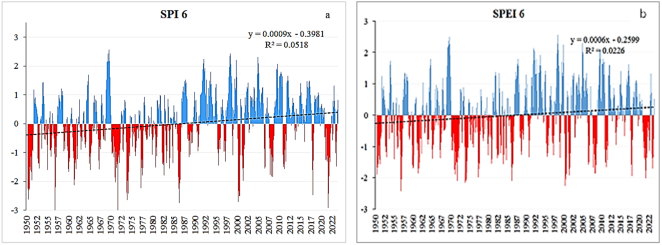
Figure 1. SPI 6 (a) and SPEI 6 (b) values of Bustonabad for the period 1950-2023.
The dynamics of the standardized precipitation index (SPI) and SPEI indices for the Bustonabad area for the period 1950-2023 is shown in Figure 1, which shows an increase in the values of the drought indices, probably related to increasing humidity over the period considered.
Figure 2 shows the number of extreme and severe droughts at Bustonabad for each decade of the period 1950-2023. From Figure 2 it can be seen that the periods 1970-1979 and 2000-2009 were the driest periods on the upper Kafirnigan River (Bustonabad), characterised by 12 severe and 4 extreme droughts and 13 severe and 3 extreme droughts respectively.
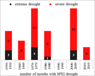
Figure 2. Number of extreme and severe droughts at Bustonabad in each decade of the period 1950-2023.
From Figure 3, which shows the trends in mean annual temperature, rainfall and drought, it can be seen that while temperature tended to increase from 1970 to 1985, rainfall also decreased. This is probably the reason for the drought at Bustonabad during the period 1970-1979.
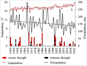
Figure 3. Trends in mean annual temperature, rainfall and number of months with drought (extreme and severe) in Bustonabad district for the period 1950-2023.
In the upstream of the Kafirnigan River (Bustonabad meteostation) in 2001, May, June, July and August are characterised as severe drought months. For the months of May and June, there is a positive deviation of the mean monthly surface air temperature from the norm of 4.3°C and 2.7°C, respectively (Figure 4).
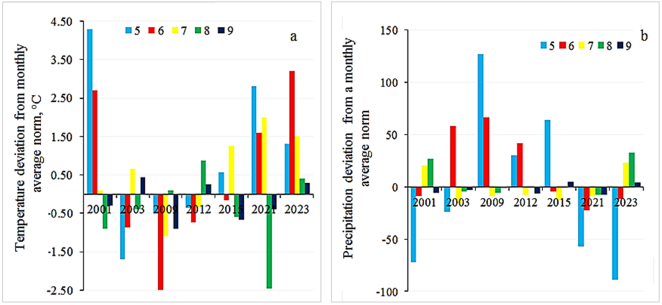
Figure 4. Deviation of mean monthly temperature (a) and rainfall (b) in the growing months from May (5) to September (9) from the annual norm at Bustonabad for the period 2001-2003 (5-May, 6-June, 7-July, 8-August, 9-September).
At the same time, the precipitation availability for the growing season from May to August was 41%, 73%, 195% and 438% of the monthly averages, respectively. The rainfall values for the months of May and June are lower than the monthly average by 72 mm and 9 mm, while in July and August they exceed the norm by 20 mm and 27 mm (Figure 4, b).
Figure 4 shows the excess of precipitation values from the monthly average norm in May, June and a slight deficit in July and August of 2009 and 2012. Characterised by negative deviations of mean monthly temperature from the norm in May and June of 2009 by -0.5°C and -2.5°C respectively and in 2012 by -0.37°C and -0.74°C, positive values of the standardized precipitation and evapotranspiration index and the standardized precipitation index are obtained (Figure 4, a).
The driest years in recent decades in the middle reaches of the Kafirnigan River were 2021 and 2023, characterised by severe drought. The monthly mean temperature exceed in May, June and July of 2021 were 2.81°C, 1.60°C and 2.0°C with precipitation deficits of -57.2 mm, -22.8 mm and -9.3 mm, respectively. In 2023, the mean monthly temperature in May, June and July exceeded the mean monthly norm by 1.3°C, 3.2°C and 1.5°C, respectively, with precipitation deficits of 89.3 mm and 11.5 mm in May and June, respectively (Figure 4, a, b).
Figure 5 shows the SPEI and SPI values from May to September of the period 2001-2023 calculated from the data of the Bustonabad weather station. As can be seen from Figure 5, the SPEI and SPI values in 2003, 2009, 2012 and 2015 are positive, i.e. no drought threat.
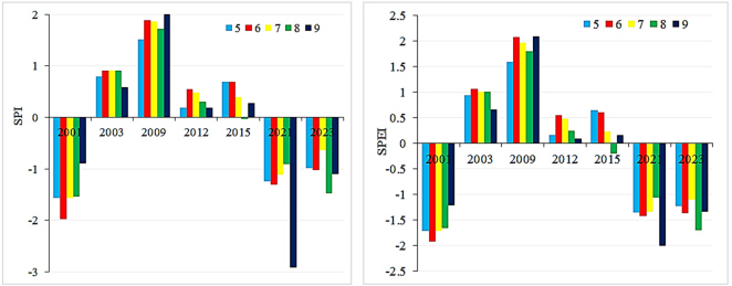
Figure 5. SPI and SPEI values of Bustonabad during the growing months of May (5) to September (9) for the period 2001-2023 (5-May, 6-June, 7-July, 8-August, 9-September).
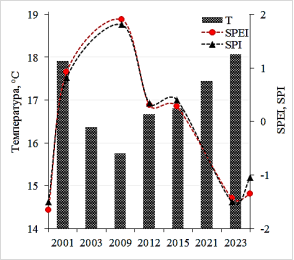
Figure 6. Variation of annual mean values of temperature, SPI and SPEI according to data from Bustonabad weather station for the period 2001-2023.
To explain this process, we refer to Figure 6, which shows the dynamics of SPI and SPEI and the annual mean temperature values for the period 2001-2023. From Figure 6 it can be seen that the years 2003, 2009, 2012 and 2015 are characterised by lower temperature values compared to the rest of the years. Therefore, it can be assumed that this will lead to positive values of SPI and SPEI.
Figure 7 shows the dynamics of the annual mean values of SPI and SPEI of the South Tajik lowlands for the period 1950-2023. The characteristic feature of the drought indices is their decrease and the significant difference in their decreasing trend.
Figure 8 shows the monthly means and the difference between the Standardised Precipitation and Evapotranspiration Index (SPEI) and the Standardised Precipitation Index (SPI). From Figure 8 it can be seen that the difference between SPEI and SPI is negative in the winter period (XII - II) and positive in the spring-autumn period (III -X). The difference between SPEI and SPI is mainly due to potential evapotranspiration (PET).
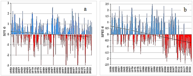
Figure 7. Dynamics of changes in SPI (a) and SPEI (b) of the southern Tajik lowlands for the period 1950-2023.
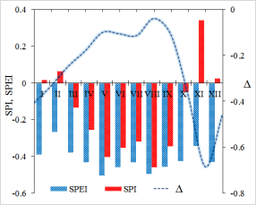
Figure 8. Annual mean monthly values of SPI and SPEI and differences SPEI and SPI (Δ) of the southern Tajik lowlands.
SPEI is an important and useful tool for comparing meteorological droughts, as it takes into account the temperature regime - as a factor leading to evapotranspiration - in addition to precipitation. The inclusion of PET makes a noticeable difference in the index values, confirming that SPEI is a drought index that is significantly different from SPI. The largest differences between SPEI and SPI are observed in summer, when PET accounts for most of the climatic water balance.
In order to establish the relationship between the standardized drought indices and the meteorological conditions of the southern Tajik lowlands, the long-term mean monthly values of precipitation and temperature were compared with the climatic norms for the area shown in Figure 9 (a, b).
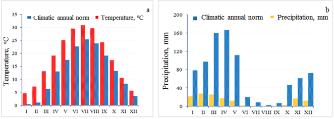
Figure 9. Monthly averages of temperature (a) and precipitation (b) in the South Tajik Lowlands for the period 1950-2023.
As shown in Figure 9(a), the monthly mean temperature values of the South Tajik Lowlands are significantly higher than the monthly mean climatic norms in all seasons. This is naturally reflected in the values of the drought indices and, as can be seen from Figure 9, negative values of SPI and SPEI dominate almost throughout the year.
A similar picture is observed in the dynamics of changes in the monthly mean values of atmospheric precipitation (Figure 9, b).
The characteristic feature of the drought indices (SPI and SPEI) in the South Tajik Lowlands is their decreasing nature and the significant difference in the trends of change. Differences between SPEI-6 and SPI-6 are due to potential evapotranspiration (PET), which is determined by the difference between precipitation and evaporation. The similarity between SPEI and SPI in winter is reasonable because PET tends to have the lowest ratio to precipitation during this period, resulting in a functional approximation of SPEI to SPI. Conversely, the largest difference is observed in November, which covers the period from June to November when PET is highest in relation to precipitation. It is found that for the period 1950-2023, monthly mean precipitation values are significantly lower and temperatures are higher than the climatic norm of the southern Tajik lowlands, leading to negative values of mean annual SPEI and SPI and favoring the occurrence of drought.
It was assumed that the potential drought condition should be determined by the ratio of rainfall to the norm of the sum of annual averages of a given locality. For example, the sum of annual mean rainfall in Ayvaj is 178 mm and in the Faizabad basin area it is about 840 mm. In Ayvaj, there is initially a large deficit in rainfall, and for this area with stressful climatic conditions, even sufficient changes in meteorological parameters do not have a noticeable impact. On the contrary, in Faizabad district, where the norm for the sum of the average annual rainfall is high, even a slight downward deviation of the rainfall from the norm can create favorable conditions for the occurrence of drought.
To verify this assumption, the changes in precipitation for the period 1950-2023 at the Ayvaj (a) (Figure 10) and Bustonabad (Figure 3) meteorological stations were compared with the frequency of extreme and severe droughts in the respective areas where the meteorological stations are located. Figure 10 shows that an increase in the frequency of extreme and severe droughts is observed in the southern areas of the Kafirnigan River basin in the last decade of the period under consideration, 1950-2023.
On the other hand, extreme and severe droughts in the northern part of the Kafirnigan River basin (in Bustonabad district) cover almost all decades of the period under consideration (Figure 3).
Figure 10 shows the mutual correlation of the SPEI values of the northern (Bustonabad) and southern (Ayvaj) parts of the Kafirnigan River basin, which shows that there is a moderate relationship between them with a correlation coefficient of 0.5.
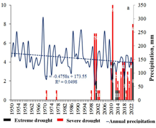
Figure 10. Dynamics of mean annual precipitation, number of months with drought in the southern (a) and northern (b) parts of the Kafirnigan River basin for the period 1950-2023.
The total number of months with drought for the period 1950-2023 despite the large difference in mean annual precipitation between the northern and southern parts of the Kafirnigan River Basin, the total number of different types of drought is similar.
The results obtained suggest that the occurrence of drought is probabilistic in nature and manifests itself under certain combinations of meteorological parameters, and that the local climatic conditions of the area are not dominant in this process.
4. Conclusion
The geographical location of the Republic of Tajikistan determines the country's high vulnerability to various climate-related natural disasters, such as floods, droughts and mudslides, which significantly affect sustainable development and people's living conditions, including their access to adequate food and drinking water.
Droughts, especially in their extreme forms, accelerate the development of desertification, the main cause of which is excessive anthropogenic pressure, which increases under conditions of prolonged and intense drought. In this context, the issue of developing and improving modern systems for monitoring and predicting droughts, as well as preparing for and mitigating their consequences, becomes extremely important.
The dynamics of changes in annual mean temperature, precipitation and drought in the upper reaches of the Kafirnigan River (Bustonabad) showed that an increase in temperature was accompanied by a decrease in precipitation during the period from 1970 to 1985. This was probably the reason for the aridity of Bustonabad for the period 1970-1979.
In recent decades, the driest years in the middle reaches of the Kafirnigan River were 2021 and 2023, characterised by severe drought. The monthly mean temperature exceedances in May, June and July of 2021 were 2.81°C, 1.60°C and 2.0°C with precipitation deficits of 57.2 mm, 22.8 mm and 9.3 mm, respectively. In 2023, the mean monthly temperature was 1.3°C, 3.2°C and 1.5°C above the mean monthly norm in May, June and July, respectively, with rainfall deficits of 89.3 mm and 11.5 mm in May and June, respectively.
In the lower reaches of the Kafirnigan River, seasonal precipitation occurs mainly in winter and spring, but in small amounts, with an annual mean of 68-79 mm. The dynamics of precipitation and temperature show opposite trends. The insignificant trend of decreasing precipitation at altitudes up to 400 m a.s.l in the southern parts of the Kafirnigan River basin is mainly related to local meteorological phenomena.
It was found that the average monthly temperature values of the southern Tajik lowlands are significantly higher than the average monthly climatic norms in all seasons. This is naturally reflected in the values of the drought indices, i.e. negative values of SPI and SPEI dominate almost throughout the year.
A characteristic feature of the drought indices (SPI and SPEI) in the southern Tajik lowlands is their decreasing nature and the significant difference in the trends of change. Differences between SPEI-6 and SPI-6 are due to potential evapotranspiration (PET), which is determined by the difference between precipitation and evaporation. The similarity between SPEI and SPI in winter is reasonable because this is the period when PET tends to have the lowest ratio to precipitation, resulting in a functional approximation of SPEI to SPI. According to the same principles, the largest difference is observed in November, which covers the period from June to November, when PET is highest in relation to precipitation. It is found that for the period 1950-2023, monthly mean precipitation values are significantly lower and temperatures are higher than the climatic norm of the southern Tajik lowlands, leading to negative values of mean annual SPEI and SPI and favoring the occurrence of drought.
Abbreviations

SPEI

Standardized Precipitation and Evapotranspiration Index

PET

Potential Evapotranspiration

SPI

Standardized Precipitation Index

KRB

Kafirnigan River Basin

SSCR model

System of Statistical Credit Ratings

RCP

Representative Concentration Pathways

Author Contributions
Inom Normatov: Conceptualization, Formal Analysis, Methodology, Supervision, Writing – original draft
Gurdofarid Saburova: Data curation, Investigation, Resources
Zarnigor Safarova: Data curation, Formal Analysis, Investigation, Writing – review & editing
Alisher Rahimzoda: Conceptualization, Data curation, Formal Analysis, Investigation, Methodology, Software, Writing – original draft
Funding
This work is not supported by any external funding.
Data Availability Statement
The data is available from corresponding author upon reasonable request.
Conflicts of Interest
The authors declare no conflicts of interest.
References
[1] United Nations Economic and Social Commission for Asia and the Pacific (UN ESCAP) Annual Report 2012: Building a resilient, inclusive and sustainable Asia and the Pacific. 2012, 43p.
[2] Hewitt, K Regions of Risk: A Geographical Introduction to Disasters. London, UK: Longman; 1997, pp. 34-36.
[3] Zerger, A., Smith, D. I Impediments to using GIS for real-time disaster decision support, Comput. Environ. Urban Sys. 2003, 27(2), 123–141.
[4] Cutter, S. L., Boruff, B. J., W. L. Shirley, W. L Social vulnerability to environmental hazards, Soc. Sci. 2003, 84(2), 242–261.
[5] Ebert, A., Kerle, N., Stein, A Urban social vulnerability assessment with physical proxies and spatial metrics derived from air-and space borne imagery and GIS data, Nat. Hazards. 2009, 48(2), 275–294.
[6] Mileti, D Disasters by Design: A Reassessment of Natural Hazards in the United States. Washington, DC: Joseph Henry Press; 1999, pp. 11-13.
[7] Szlafsztein, C., Sterr, H GIS-based vulnerability assessment of coastal natural hazards, state of Par´a, Brazil, J. Coast Conserv. 2007, 11(1), 53–66.
[8] Uitto, J. I The geography of disaster vulnerability in megacities: a theoretical framework, Appl. Geogr. 1998, 18(1), 7–16.
[9] Wisner, B., Blaikie, P. M., Blaikie, P., Cannon, T., Davis, I Risk: Natural Hazards, People’s Vulnerability and Disasters. Brighton, UK: Psychology Press, 2004, pp. 3-6.
[10] Juntunen, L Addressing social vulnerability to hazards, Dis. Safety. Rev. 2005, 4(2), pp. 3–10.
[11] White, G. F Natural Hazards, Local, National, Global. Oxford, UK: Oxford University Press, 1974, pp. 17-20.
[12] Flanagan, B. E., Gregory, E. W., Hallisey, E. J., Heitgerd, J. L., Lewis, B A social vulnerability index for Disaster management, J. Homel. Secur. Emerg. 2011, 8(1), pp. 31-33.
[13] Pelling, M. Visions of Risk: A Review of International Indicators of Disaster Risk and Management United Nations International Strategy for Disaster Reduction (UNISDR), 2004. 89p.
[14] Peduzzi, P The disaster risk, global change, and sustainability nexus, Sustainability. 2019, 11(4), pp. 954-957.
[15] Aubrecht, C., D. Ozceylan, D., Steinnocher, K., Freire, S Multi-level geospatial modeling of human exposure patterns and vulnerability indicators, Nat. Hazards. 2013, 68(1), 147–163.
[16] Brooks, N Vulnerability, risk and adaptation: a conceptual framework, Tyndall Centre for Climate Change Research, Working Paper. 2003, 38, pp. 1-16.
[17] Fuchs, S Susceptibility versus resilience to mountain hazards in Austria: paradigms of vulnerability revisited, Nat. Hazards Earth Syst. Sci. 2009, 9, 337–352.
[18] Cutter, S. L., Mitchell, J. T., Scott, M. S Revealing the vulnerability of people and places: a case study of Georgetown County, South Carolina, Ann. Assoc. Am. Geogr. 2000, 90(4), 713–737.
[19] Hayes, M. J Drought Indices, Van Nostrand’s Scientific Encyclopedia, NJ, USA: John Wiley & Sons, Inc.: 2006, pp. 21-24.
[20] Gupta, S Central Asia and Caucasus Disaster Risk Management Initiative (CACDRMI): Risk Assessment for Central Asia and Caucasus Desk Study Review (CAC DRMI): Risk Assessment for Central Asia and Caucasus Desk Study Review. Technical Report. 2009, 173p.
[21] Füssel, H. M Vulnerability: a generally applicable conceptual framework for climate change research, Global Environ. Change. 2007, 17(2), 155–167.
[22] Wheeler, R. S., Haddad, L Reconciling different concepts of risk and vulnerability: a review of donor documents, Acceso. 2005, 12(5), pp. 3-6.
[23] Gitz, V., Meybeck, A Risks, vulnerabilities and resilience in a context of climate change, Building resilience for adaptation to climate change in the agriculture sector. 2012, 23, pp. 17-19.
[24] White, C., Tanton, T., and Rycroft, D The Impact of Climate Change on the Water Resources of the Amu Darya Basin in Central Asia, Water Resource Management. 2014, 28, pp. 5267–5281.
[25] Pritchard, H. D Asia’s shrinking glaciers protect large populations from drought stress. Nature. 2019, 569(7758), p. 649. URL:
[26] Naumann, G., Alfieri, L., Wyser, K., Mentaschi, L., Betts, R. A., Carrao, H., Feyen, L Global Changes in Drought Conditions Under Different Levels of Warming, Geophysical Research Letters. 2018, 45(7), pp. 3285–3296.
[27] Gulakhmadov, N. A., Chen Y Analysis of multi-year temperature trends in the basin of the Kafirnigan River in Tajikistan, Scientific and Technical Bulletin of Bryansk State University. 2023, 2, pp. 189–203.
[28] Saburova, G. N., Normatov, I. Sh Dynamics of meteorological characteristics and evapotranspiration of the lower Kafirnigan River (Tajikistan) - a tributary of the transboundary Amu Darya River for the period 1946-2021, Izvestiya of Saratov University, Earth Sciences. 2024, 24(1), pp. 26–31.
[29] Pendergrass, A. G., Knutti, R., Lehner, F., Deser, C., Sanderson, B. M Precipitation variability increases in a warmer climate, Scientific reports. 2017, 7, p. 17966.
[30] Gulakhmadov, A. A Assessment of trends and magnitude changes in precipitation over the last decades in the Kafirnigan River Basin, Bulletin of Pedagogical University (Natural Sciences). 2021, 1-2(9-10), pp. 8-18.
Cite This Article
  • APA Style

    Normatov, I., Saburova, G., Safarova, Z., Rahimzoda, A. (2025). Droughts in the High Continental Climate of Central Asia. International Journal of Atmospheric and Oceanic Sciences, 9(1), 9-18. https://doi.org/10.11648/j.ijaos.20250901.12

    Copy | Download

    ACS Style

    Normatov, I.; Saburova, G.; Safarova, Z.; Rahimzoda, A. Droughts in the High Continental Climate of Central Asia. Int. J. Atmos. Oceanic Sci. 2025, 9(1), 9-18. doi: 10.11648/j.ijaos.20250901.12

    Copy | Download

    AMA Style

    Normatov I, Saburova G, Safarova Z, Rahimzoda A. Droughts in the High Continental Climate of Central Asia. Int J Atmos Oceanic Sci. 2025;9(1):9-18. doi: 10.11648/j.ijaos.20250901.12

    Copy | Download

  • @article{10.11648/j.ijaos.20250901.12,
      author = {Inom Normatov and Gurdofarid Saburova and Zarnigor Safarova and Alisher Rahimzoda},
      title = {Droughts in the High Continental Climate of Central Asia},
      journal = {International Journal of Atmospheric and Oceanic Sciences},
      volume = {9},
      number = {1},
      pages = {9-18},
      doi = {10.11648/j.ijaos.20250901.12},
      url = {https://doi.org/10.11648/j.ijaos.20250901.12},
      eprint = {https://article.sciencepublishinggroup.com/pdf/10.11648.j.ijaos.20250901.12},
      abstract = {Drought, one of the manifestations of emergencies, is a serious problem for Central Asia. Experts estimate that more than 70 per cent of the region's territory is considered vulnerable to natural disasters. Droughts are less frequent than floods, but affect more people. Over the past decade, 60 per cent of the population exposed to extreme weather events has been affected by drought. The most tangible impact of drought is on agriculture and food security in the region. Droughts are expected to become more frequent in Tajikistan, Turkmenistan and Uzbekistan due to projected temperature increases and longer periods of extreme heat and evaporation in areas with lower precipitation. In establishing drought monitoring and early warning systems in Central Asia and adapting drought prediction models, the monitoring of climate indicators and the availability of a rich and deep database of years is an important link. The purpose of this work is to monitor the probability of drought occurrence depending on the meteorological conditions of the Kafirnigan River basin in Tajikistan. The formation and dispersion zones of the Kafirnigan River differ significantly in their meteorological characteristics. The monitoring of droughts in the area of the river's formation and dispersion and their comparison with meteorological conditions allows establishing the existence of certain regularity between them. The results of such dependencies can form the basis for the development of drought early warning systems. A characteristic feature of the drought indices (SPI and SPEI) in the southern Tajik lowlands is their decreasing nature and the significant difference in the trends of change. Differences between SPEI-6 and SPI-6 are due to potential evapotranspiration (PET), which is determined by the difference between precipitation and evaporation. The similarity between SPEI and SPI in winter is reasonable because this is the period when PET tends to have the lowest ratio to precipitation, resulting in a functional approximation of SPEI to SPI. According to the same principles, the largest difference is observed in November, which covers the period from June to November, when PET is highest in relation to precipitation. It is found that for the period 1950-2023, monthly mean precipitation values are significantly lower and temperatures are higher than the climatic norm of the southern Tajik lowlands, leading to negative values of mean annual SPEI and SPI and favoring the occurrence of drought.},
     year = {2025}
    }
    

    Copy | Download

  • TY  - JOUR
    T1  - Droughts in the High Continental Climate of Central Asia
    AU  - Inom Normatov
    AU  - Gurdofarid Saburova
    AU  - Zarnigor Safarova
    AU  - Alisher Rahimzoda
    Y1  - 2025/02/11
    PY  - 2025
    N1  - https://doi.org/10.11648/j.ijaos.20250901.12
    DO  - 10.11648/j.ijaos.20250901.12
    T2  - International Journal of Atmospheric and Oceanic Sciences
    JF  - International Journal of Atmospheric and Oceanic Sciences
    JO  - International Journal of Atmospheric and Oceanic Sciences
    SP  - 9
    EP  - 18
    PB  - Science Publishing Group
    SN  - 2640-1150
    UR  - https://doi.org/10.11648/j.ijaos.20250901.12
    AB  - Drought, one of the manifestations of emergencies, is a serious problem for Central Asia. Experts estimate that more than 70 per cent of the region's territory is considered vulnerable to natural disasters. Droughts are less frequent than floods, but affect more people. Over the past decade, 60 per cent of the population exposed to extreme weather events has been affected by drought. The most tangible impact of drought is on agriculture and food security in the region. Droughts are expected to become more frequent in Tajikistan, Turkmenistan and Uzbekistan due to projected temperature increases and longer periods of extreme heat and evaporation in areas with lower precipitation. In establishing drought monitoring and early warning systems in Central Asia and adapting drought prediction models, the monitoring of climate indicators and the availability of a rich and deep database of years is an important link. The purpose of this work is to monitor the probability of drought occurrence depending on the meteorological conditions of the Kafirnigan River basin in Tajikistan. The formation and dispersion zones of the Kafirnigan River differ significantly in their meteorological characteristics. The monitoring of droughts in the area of the river's formation and dispersion and their comparison with meteorological conditions allows establishing the existence of certain regularity between them. The results of such dependencies can form the basis for the development of drought early warning systems. A characteristic feature of the drought indices (SPI and SPEI) in the southern Tajik lowlands is their decreasing nature and the significant difference in the trends of change. Differences between SPEI-6 and SPI-6 are due to potential evapotranspiration (PET), which is determined by the difference between precipitation and evaporation. The similarity between SPEI and SPI in winter is reasonable because this is the period when PET tends to have the lowest ratio to precipitation, resulting in a functional approximation of SPEI to SPI. According to the same principles, the largest difference is observed in November, which covers the period from June to November, when PET is highest in relation to precipitation. It is found that for the period 1950-2023, monthly mean precipitation values are significantly lower and temperatures are higher than the climatic norm of the southern Tajik lowlands, leading to negative values of mean annual SPEI and SPI and favoring the occurrence of drought.
    VL  - 9
    IS  - 1
    ER  - 

    Copy | Download

Author Information
  • Meteorology and Climatology Department, Tajik National University, Dushanbe, Tajikistan

    Biography: Inom Normatov is a Corresponding Member of the National Academy of Sciences of Tajikistan, Professor, Head of the Department of Meteorology and Climatology at the Tajik National University. He defended his doctoral thesis in 1993. From 2002 to 2009 he was the Director of the Institute of Water Problems, Hydropower and Ecology of the National Academy of Sciences of Tajikistan.

    Research Fields: Meteorology, Climatology, Agrometeorology, Hydrochemistry, Glaciology

  • Ecology Department, Tajik National University, Dushanbe, Tajikistan

    Biography: Gurdofarid Saburova is an assistant at the Department of Ecology, Tajik National University. She is working on her dissertation on 'Influence of meteorological conditions of the Kafirnigan River basin on the formation of river runoff' and is the author of more than 15 scientific articles.

    Research Fields: Meteorology, Climatology, Ecology, Hydroecology, Hydrobiology

  • Agrometeorology Department, Tajik Hydrometeorology Agency, Dushanbe, Tajikistan

    Biography: Zarnigor Safarova is employer of the Agrometeorology Department of the Hydrometeorological Agency of Tajikistan. She is working on her PhD on the study of drought in the river basins of Tajikistan. Author of more than 10 scientific papers.

  • Hydromechanics Department, Mathematics Institute of the National Academy of Science of Tajikistan, Dushanbe, Tajikistan

    Biography: Alisher Rahimzoda is a leading researcher at the Institute of Mathematics of the National Academy of Sciences of Tajikistan, doctor of physical- mathematical science. He defended his Ph.D. thesis at the Institute of Mathematics of the National Academy of Sciences of Tajikistan in 2017. Currently, he is the head of the Department of Mathematical Description of Meteorological Processes of Central Asian River Basins.

    Research Fields: Mathematical Modeling, Correlation, Hydrology, Meteorology, Hydrological Prognosis